Tuesday, July 29, 2014

Tuolumne Meadows to Mammoth

I should never underestimate the power of restriction. That is, regarding photography. To change my perspective while on a backpacking trip from Yosemite's Tuolumne Meadows to a place called Agnew Meadows near Mammoth Lakes, I limited myself to a 70-200mm lens while hiking. I had noticed that I wasn't happy with my pictures lately—that the background was getting pushed back too much with my reliance on a 24-70mm lens. Granted, while I was in camp I allowed myself the use of a 16-35mm lens but I found I didn't really use it that much. Most of the time, when I needed a wider shot, I took a series of pictures with the long lens so I could stitch them together later. In that way, I maintained the compressed perspective I was trying to achieve.

I'm going to have to do this more often. I really liked the results.


Our group of eight at the start. A combination of two pictures to get the best smiles.
Hiking through the early morning steam coming off the wet ground.
Cammy, Jerri and Reid crossing the Tuolomne River in what Reid said was an impersonation of the Abby Road album cover. They look more like something out of Monty Python, I think.
Yours truly hoofing it through Lyell Canyon after about three miles in my humble version of the selfie (done with a wireless remote). I didn't look quite so fresh for much longer.
Grass along the Tuolomne River bank.
Steps leading into a river crossing.
Approaching storm clouds over Lyell Canyon that later dumped on us after we set up camp.
Reid taking a break at the Tuolomne River.
The river passing our campsite. Shot at an exposure of 30 seconds with a ten-stop neutral density filter.


Another selfie. This time crossing a lake outlet on the climb to 11,000' Donahue Pass.
One more selfie. Hiking away from Donahue Pass.

This marmot later tried to steal my GPS while I was recharging it with a solar panel. Don't like marmots.
Clouds near Donahue Pass.
Approaching storm clouds just south of Thousand Island Lake. They never hit us, fortunately.

Yours truly praising the gods for such fine weather while Reid sips from the lake.

Reid cooling off in Thousand Island Lake with Banner Peak behind him.

The gang relaxing on the grassy shore.
This woman was doing yoga poses across from us and I couldn't resist taking a few pictures.

The traditional quesadilla night meal.

Our cramped camp at Thousand Island Lake.

Sunset, Thousand Island Lake and Banner Peak.

One of several fish that Kirk caught at Thousand Island Lake. He released all of them.

Early morning, Thousand Island Lake and Banner Peak.
Garnet Lake with Mt. Ritter (left) and Banner Peak.
The creek at our last camp above Lake Ediza. Mt. Ritter and Banner Peak are in the background.

Kirk crossing the creek on the final morning.

Annette and Reid dipping into Shadow Creek for water.

Storm clouds over Mammoth Mountain as we descended from Shadow Lake.

Tuesday, July 15, 2014

Eaton Canyon

After talking about it for what seemed like years, the U.S. Forest Service has announced that it's shutting down the bottom portion of Eaton Canyon to everyone (well, it was actually a stealth announcement; there were no public hearings). The canyon is a spectacular, waterfall-filled gouge running down through the San Gabriel Mountains above Pasadena (near Los Angeles). The reason for the closure is both to save people from themselves (five hikers have died in the last four years while trying to go up a steep, crumbly trail at the bottom of the canyon) and presumably financial (one ranger told me they spend half a million dollars on rescues every year). You might think this wouldn't affect the many canyoneers starting at the top of the canyon and (sort of safely) going down with ropes, harnesses and rappel devices. But if they're caught in the closure zone at the bottom, they'll be fined.

Perhaps this will all be settled soon. There's talk of instituting a permit system for canyoneers. But it does set up an interesting issue of how a fairly reckless group of unprepared people going up the canyon can impact another group of largely prepared people going down the canyon. (The same ranger who told me about the rescue price tag also said they've pulled out people who saw videos of the canyon, bought rope from Home Depot, and tried to go down the canyon, minus any significant training or experience, and got into trouble of one sort or another. So this isn't just the clueless kids unable to recognize the obvious dangers of climbing up a wet, slippery canyon.)

Or, the canyon could be shut down for a long time. You never know.

With all of this in mind, I gathered together a few shots from my three trips through the canyon as a reminder of what a wonderful place this is.

Here's the problem: this lad climbed up a rotten, precipitous trail to get to this waterfall so he could jump off the 80-footer into a pool just deep enough to keep him from busting his body into pieces.
The canyon's final rappel coincides with a waterfall that people hike up to on an easy, almost flat trail. But unfortunately, some of them don't stay there but press on up the crumbly trails to the next fall or beyond where it gets slippery and even more dangerous.

Wednesday, July 9, 2014

Telephone Canyon

I don't mind saying that I quivered like a little girl when I saw the first rappel in Telephone Canyon. What a beast. It was 185 feet of sheer rock that peeled back not far from the top to leave a long free rappel that just felt so exposed. After Rich went down first, I volunteered to go next. Usually, I do that because I want to get in a good position for pictures. Not this time. I just wanted to get it over with.

I don't know. For some reason, I just lost my nerve. And as soon as I hit the spot where my toes desperately stretched out but no longer touched rock, I felt incredibly insecure. I started to spin on the rope. I felt like I didn't have enough friction on my rappel device and if I went any faster, I'd lose control. I was half a heartbeat away from pure panic.

Somehow I got down okay, but the rest of the canyon was a rough conglomeration of more than a dozen rappels, none of them easy. Many included chock stones at the top that required special maneuvering just to get started. There were slanted slots too narrow for our packs. My legs were scraped. I got a rope burn.

And yet, I think I'm glad I did it and would actually return for a second run-through. Something about a good, old fashioned challenge, I guess.

Telephone Canyon is located in Zion National Park and requires a lengthy, uphill hike past Angel's Landing just to get to that first, colossal rappel. Recommended only for experienced canyoneers, I would say.

Angel's Landing from the trail. People can either take a trail that goes along the spine of the rock, or just climb up the wall. My vote goes to the trail.
Hiking up and up.
Arriving at the top of the canyon. My stomach turned over at the first sight of it.
Rich (bottom center of the photo) on the first rappel.
Annette showing me how it's done on the free rappel.
Annette about to work her way past a dank pool at the bottom of the first rappel.
Kevin working his way past the same dank pool.
Jerri, the last one down the first rappel, managing the pull rope.
Rich working his way down a free rappel with Kevin belaying.
Rich starting the long hike out over slickrock.

Wednesday, July 2, 2014

Keyhole Canyon

I have mixed feelings about Keyhole Canyon in Zion National Park. The first time I went through it was two or three years ago and it was canyoneer heaven. Beautiful light even if it was quite dark, deep but freezing cold water, a few slightly challenging segments, but all of it fun. My wife, Gloria, was with me and that made a difference, too, sharing the canyon with her. Unfortunately, just before we got out of the dark corridors and into Zion's bright sunshine, I slipped while in waist-high, murky water and my camera with a flash took a good dunk. I had gotten cocky. Throughout the two-hour excursion, anytime I was in deep water, the camera was safe inside two dry sacks. And whenever I was sloshing through waist-deep water, I held the camera above my head. And then near the end, without thinking, I held the camera only as high as my chest. My feet, feeling about the bottom of the water for purchase, went into a hole. Splunk. If the camera had been above my head, it might not have gone in. Oh, well, I thought. I've got insurance. I got cocky there, too. I had been doing some wild things in the mountain climbing department and busted a few camera parts the previous year. So the insurance company balked at paying for more expensive equipment. Eventually, they relented after I filed a complaint with the state's insurance commission, but afterward, they cancelled my policy.

So the second time I entered the canyon last month, I was ever so careful. But strangely, I didn't see so much to photograph this time. We blasted through the canyon and that was that. I did get a few pictures, however. Can't leave a canyon without a few shots.

The canyon approach climbing up slickrock.
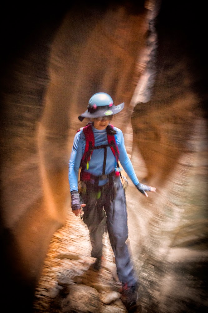
Jerri making her way through the first of the slots.

The first rappel into murky, yucky, cold water that came up to my neck. Notice how smooth and rounded the pothole is. Climbing out involved grabbing a nubbin of rock and heaving my body over the edge.
Others had help getting out of the pothole.
My pack.